Category: Uncategorized

  • Northern Snowdonia Circular Featuring the Lon Las Eryri

    I wanted to create a bikepacking circuit that incorporated the excellent Lon Las Eryri—a fantastic, traffic-free cycle route west of the mountains. The best section runs south from Caernarfon to Criccieth. It’s level, well-surfaced, and incredibly scenic. You feel as though you’re floating through fields, with the sea on your right and the mountains of Snowdonia on your left. Even the more enclosed sections further north are interesting, winding through Caernarfon and wooded glades alive with native trees and singing birds.

    When I realised I could complete the circuit by including sections of the Penmachno and Gwydyr mountain bike trails, I knew we had a good route. I’ve since tweaked it to avoid Bangor more than I did on my original trip. The lanes that NCN 5 follows near Bangor are litter-strewn, often host to unsavoury activity, and generally unpleasant. The revised route now uses quieter country lanes further south. While there’s quite a bit of tarmac overall, it’s mostly peaceful country roads that provide pleasant riding and link the off-road sections well.

    There’s one decent push—from Croesor Mine to Rhosydd Mine—but it wouldn’t be bikepacking without a bit of a hike-a-bike, would it?

    I started in Trefriw with my friend Richard. You can safely leave a car in Trefriw at the parking on Gower Road (opposite the Woollen Mill) for several days. If arriving by train, Conwy is a good entry point, or if timings work, Llanrwst North station is even closer.

    From Trefriw, woodland paths help you avoid the unpleasant B5106, though it’s a long climb up to Bwlch y Ddeufaen. From there, it’s brilliant off-road riding—mostly downhill with great views out to sea and Anglesey—along an ancient trackway. This was the original “coastal” route across North Wales, used even before the Romans, who later formalised it. Now it’s ours!

    If you’re on holiday, take a detour to see the Aber Falls, and maybe grab a bite at the lovely café in Abergwyngregyn. From there, join National Cycle Route 5 towards Bangor. To avoid Bangor, continue towards Rachub—this is where I’ve re-routed the track for a more pleasant and interesting alternative. You’ll catch a beautiful slice of the Lon Las Ogwen cycleway, complete with a tunnel, before quiet lanes lead you across to the Lon Las Eryri.

    Follow the Lon Las Eryri south—we stopped for a curry in Caernarfon—but be aware that camping spots are sparse in this area. We managed a sneaky one far from any homes, though we still encountered a few dog walkers! Staying in Caernarfon or the Penygroes area could be a good alternative.

    Leaving the Lon Las Eryri is a shame, but the following lanes are lovely—especially the high ground near Llyn Du. Just before reaching Llyn Du, a detour to visit the Slate Mill is worthwhile. Then it’s full steam ahead to the brilliant Carreg Shop and Café in Llanfrothen—a must-visit refuelling stop.

    Now the hills begin. Croesor is charming, with another small café. The route climbs into Cwm Croesor, leading into slate mining country—a World Heritage Site. After a bumpy descent, you’ll enjoy a lovely ride through Cwmorthin. It’s tarmac again for a stretch, and while the climb up Cwm Teigl should be manageable, fatigue may be setting in by then. We camped at the Rhiwbach Quarry—quiet, sheltered, and a great spot.

    Drop down to Penmachno—there’s a shop and bunkhouse if needed—then climb up to join the Dolen Eryri Trail, which offers a pleasant lead-in to a fast descent into Betws-y-Coed, where you’ll find all the amenities you could want. From there, it’s the latter half of the Gwydir Fawr Trail (formerly the Marin Trail), which ends with a fantastic descent to Sawbench, then a sneaky route through the woods back to Trefriw. Stay off the road here—it’s horrible!

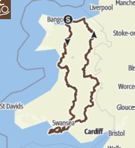
    At 87 miles with 3,000 metres of ascent, this route includes some very fast sections and some very slow ones, with plenty of lovely places to stop. I recommend taking three days to complete it. It’s not really one to race—take your time, enjoy the quick bits on the Lon Las Eryri, and revel in the slower, scenic sections. It’s varied, and it’s very, very good.


  • Round Rhinogiau – Cylchdaith Rhinogiau

    Round Rhinogiau – Cylchdaith Rhinogiau

    This is a brilliant bikepacking round. It has everything: mountains, lakesides, ancient and new woodlands, and sea views. It feels remote, yet passes through good resupply points. It’s great for wild camping, campsite stays, or even more luxurious accommodation. It includes singletrack, doubletrack, pushing track, a major cycle path, and some very nice, quiet country lanes.

    Start: Begin at the Lakeside Café near Trawsfynydd Power Station. There’s a car park a little way towards the power station where you can leave a vehicle. Since the route is circular, you can of course start wherever suits you best.

    On a three-day trip, you might camp wild at Pont Scethin—there’s a good site just downstream of the bridge—and again somewhere in Cwm of the Afon Melau.

    There are two tempting campsites: one at Cwm Nantcol and another at Cefn Maelan near Dolgellau. For a two-day option, I’d consider the bunkhouse near Barmouth and travel as light as possible. Off-season hotelling is also a good choice—cheaper than you might think—with Llanbedr and Dolgellau making ideal stopovers.

    It’s slightly surreal how nice the route is at the start, as you cycle through lakeside native woodlands with a decommissioned nuclear power station on your right. This is followed by a very tidy dam controlling the flow to a hydroelectric station at Maentwrog. The track here is level and tempting enough to continue around the lake (my GPS track shows that I did!), but you should turn right not long after the hydro dam. A bumpy track runs along a conduit—likely to deter gravel bikers. After some pushing over rough ground and along a drainage ditch, you’ll reach Nant Pasgan-mawr, an attractive ruin. It’s a lovely area, though expect a bit of a bog and some pushing.

    The uphill bridleway heading west is a definite push, but it’s a beautiful old track steeped in history. A roofless ruin on your left might make a good spot for a break. Continue uphill until you can turn right—it’s marked as a footpath, but it feels like an old, well-travelled route. This ancient way leads up to Bryn Cader Faner. The track is built-up and surfaced in places, and it steepens toward the end with some boggy crossings. This is real “wild” bikepacking! Look for a curious bit of wall on your right—ideal for leaning your bike while you visit the Bronze Age site.

    Bryn Cader Faner is an exceptional archaeological site, considered one of the wonders of prehistoric Wales. It’s well worth dismounting to marvel at a structure built by our ancestors over 3,000 years ago.

    From here, it’s a fantastic ride south on flowing tracks, mostly gently downhill and very enjoyable. There’s the occasional push, but nothing too challenging. Head to the south of Moel Geodog, eventually joining tarmac.

    Now come some great lanes—fast enough to make up time, but don’t miss Coed Crafnant, which deserves appreciation. There’s a possible stopover at Campsite Dinas, then another at Cwm Nantcol.

    Just when you’re tired of tarmac, a rough track heads southeast to Pont Scethin.

    Pont Scethin is a real gem—an 18th-century packhorse bridge, once a main route to London from Harlech. Its converging walls guided livestock across its narrow span. The bridge is a beautiful stone structure adorned with polypody ferns and maidenhair spleenwort. It’s a place to linger, with a good wild camping spot just downstream. The bridge stands as a man-made jewel amidst a landscape scarred by overgrazing—featureless hills of rush, mat grass, and purple moor grass, with few birds beyond meadow pipits. To make matters worse, the track is badly damaged by off-road vehicles. The ruts make cycling impossible in parts. Surely this can’t be sustainable—or appropriate?

    Next comes a big push—up to 560m above sea level. You might wish you were riding down instead, but the reward is worth it. The descent via Braich is sensational. On a clear day, the views are spectacular. After a few rough ruts, the riding becomes fast and flowing. Even the slower sections are historic and satisfying, as you eventually roll down to Barmouth at sea level.

    Now for the easy bit.

    Barmouth Bridge is a highlight in itself. Opened in 1867, it’s the longest and oldest wooden viaduct in use in Britain—and it has a cycle path. This leads onto the iconic Mawddach Trail—a route some mountain bikers scoff at, but in a loop like this, it’s perfect. Nine miles of flat, off-road riding give you time to look around. The estuary is rich in birdlife and native woodlands. While the history of the old railway line is well recorded, the conversion into a trail isn’t. Likely one of the earliest rail-to-trail efforts—kudos to Snowdonia National Park. Before you know it, you’re in Dolgellau.

    I’ve arrived in Dolgellau by bike before and found it tricky. The cafés are small, the pavements narrow, and there’s nowhere to safely leave a bike. After circling past impatient locals, I’ve tried two cafés—neither worth a revisit. I ended up eating Co-op snacks under the trolley bay in the rain.

    Quiet lanes now lead uphill to the hamlet of Llanfachreth, and from here the quality steps up. Quiet bridleways cross the hillsides through beautiful woodland with wonderful views. No need to rush. You’ll eventually descend past the delightfully named Ystum-gwadnaeth (with its tennis court!), nervously hoping you’re not losing too much height.

    But don’t worry—your left turn is obvious. A steady, enjoyable climb leads up to old mines below Moel Cors-y-Garnedd. Through the scrappy woods of Ffridd y Castell, you’ll suddenly notice your track contouring dramatically around the hillside, to the forested bwlch between Rhobell Fawr and Dduallt. This is truly superb riding.

    A final climb up a forestry road brings you to the summit and a standing stone. Then it’s downhill again—great mountain biking through woods and onto a hydro track, dropping into the upper Afon Mawddach valley. It’s a great place just to be.

    Tarmac gives way to forestry trails—ignore most of the bridleway signs. A beautiful riverside trail eventually leads you to the Coed y Brenin Gold Mines. It might feel surreal to suddenly join the Coed y Brenin MTB Trails—after so much quiet and remoteness, it’s a shock to see families zipping past on the Minotaur Trail, conquering what to a six-year-old must feel like Alpine passes.

    Cross a bridge and turn left, then cross another and double back at Ferndale, heading up to NCN 82. It’s a long climb, but your last. From here, it’s minor roads all the way back to where you started.

    The way is clear, simple—and downhill—back to the Lakeside Café. The smart will time their arrival for breakfast.


    This truly is a “best of everything” round—varied, ever-changing, and memorable. The slow bits deserve your full attention, and the fast ones will still make you pause to admire your surroundings. I’m looking forward to a return trip in better weather.

    The GPX files

  • The Welsh 550

    The Welsh 550 is a mountain bike trail around Wales. Widely regarded as one of the spiritual homes of mountain biking, it’s fitting that Wales has several long-distance bikepacking routes. This trail includes some of the original tracks that helped bring mountain biking to the region, as well as many of the modern, purpose-built trails that are so popular today. It is the variety of trails and the contrasting landscapes that make this such a special journey.

    The Cylchdaith Cymru 550 travels from the north coast of Wales to the south coast and back again. It crosses Snowdonia, the Cambrian Mountains, and the Black Mountain range on the journey south. On the return north, it visits the Brecon Beacons, the Radnorshire Hills, the Berwynion, and the Clwydian Hills. Along the way, riders will experience the superb cycleways of the South Wales Valleys, significant stretches of coastal path on both the north and south coasts, and plenty of woodland trails. Underwheel, expect rock, mud, shale, gravel, grass, and tarmac. The route makes use of bridleways in various states of repair, quiet lanes, forest tracks, and designated cycleways.

    What truly makes this trail stand out is its variety. In a single day, you can pass from coast to moor, from coniferous plantations to native woodland, from quiet lanes to ancient deserted roads. You will encounter few people between the north and south coasts—Wales is quiet, and it is hilly.

    For those with time to spare, pilgrimages can be made to trail centres, villages, and other places of interest, such as ancient monuments.

    Accommodation will sometimes require wild camping, though riders are encouraged to make use of campsites, hostels, B&Bs, and other available options.

    GPX

    Part One

    Part Two

    Part Three

  • Who am I?

    I’m Mike Raine, Outdoor Trainer, natruralist and bikepacker. I discovered bikepacking ten years ago, but in the last five have done a lot. I intend to bring you news, stories and learning from rides. Perhaps you’ve seen my book? Riding My Bike a bikepacker’s tales from the trails?